Topcon Terrestrial 3D Laser Scanners
The fastest, smartest way to capture reality and verify construction layouts in the field.
Choose Your Terrestrial Scanning Platform
Engineered for portability, accuracy, and efficiency. Select between high-density standalone 3D laser scanning and a fully integrated scanning robotic total station to optimize your everyday jobsite workflows.

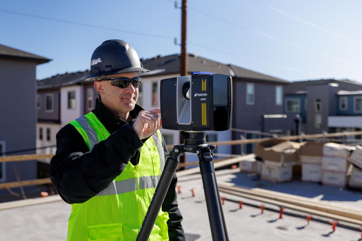
Topcon CR-P1
High-Speed 3D Laser Scanner
The Topcon CR-P1 is a compact, lightweight, and high-speed 3D laser scanner built for today’s construction, architecture, and engineering professionals. Delivering scan speeds up to 2 million points per second with real-time field registration, it simplifies data collection for building designs, large renovation sites, as-built plans, and progress tracking.
| Max Scan Speed | Up to 2,000,000 points per second |
| Range Variants | CR-P1 S (100): Up to 330 ft (100 m) | CR-P1 M (200): Up to 656 ft (200 m) |
| 3D Accuracy | 2 mm (±0.08″) @ 10 m / 3.5 mm @ 25 m |
| Field of View | 360° Horizontal × 300° Vertical |
| Imaging System | 13 MPx HDR Camera with bracketed exposures |
| Drivable Weight | 4.4 kg including internal battery |
| Protection Class | IP54 Dust- and splash-resistant |
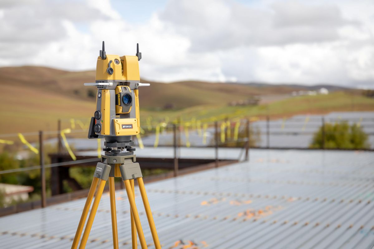
Topcon GTL-1203
Scanning Robotic Total Station
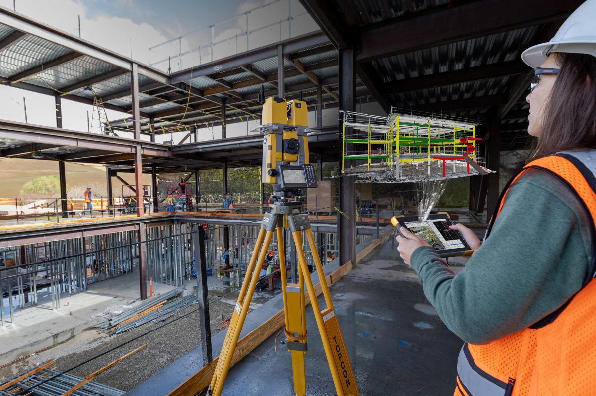
The Topcon GTL-1203 is an advanced, single-operator solution integrating high-precision robotic layout with high-speed full-dome 3D laser scanning. Purpose-built to eliminate separate workflows, it delivers instant geo-referenced point clouds, direct BIM verification, and total station positioning accuracy to accelerate construction quality.
| Scan Speed | 200,000 points per second |
| Scanning Range | Up to 230 ft (70 m at 90% reflectivity) |
| Angular Accuracy | 3″ Total Station level accuracy |
| Field of View | 360° Horizontal × 270° Vertical |
| Scanning Noise | 5 mm (0.2″) at 33 ft (10 m) |
| Surface Accuracy | 3 mm at 33 ft (10 m) |
| Advanced Imaging | Integrated 5 MP panoramic and telephoto cameras |
| Protection Class | IP54 Dust- and splash-resistant housing |
What Is a Terrestrial 3D Laser Scanner?
The Short Answer
A terrestrial 3D laser scanner is a reality capture instrument that rapidly collects millions of measurements to create detailed three-dimensional models of existing conditions. Rather than capturing individual points, it records entire environments in minutes, providing comprehensive documentation for construction and engineering projects.
How It Works
The instrument uses high-speed laser scanning to measure the distance and location of surrounding surfaces. As it operates, it captures millions of points that form a dense point cloud of the project site. Integrated software allows operators to register scans, verify coverage, and perform preliminary analysis directly in the field, ensuring complete data capture and eliminating the need for costly return visits.
Why Terrestrial 3D Laser Scanners for Construction
Topcon terrestrial laser scanners streamline reality capture workflows from field collection through final deliverables. Their seamless integration with processing and modeling software allows teams to compare existing conditions against BIM models, verify construction progress, and identify potential conflicts early. By enabling rapid data collection, in-field quality control, and accurate digital documentation, these scanners help teams make faster, more informed project decisions.
")
Key Capabilities
- ✓ Scan speeds up to 2 million points per second
- ✓ Integrated robotic layout and 3D scanning in one instrument
- ✓ Easy, independent one-person field operation
- ✓ Real-time scan registration directly on the job site
- ✓ Extended scanning ranges reaching up to 656 feet
- ✓ High-precision data capture with 2 mm 3D accuracy
- ✓ Direct BIM verification via Verity and Navisworks
- ✓ High-resolution colorization with HDR and panoramic cameras
- ✓ Wireless transfer and cloud uploads via Wi-Fi and Bluetooth
- ✓ Rugged, dust- and splash-resistant IP54 housing
Built for Survey and Construction
The terrestrial scanning lineup handles the full spectrum of positioning work, from detailed surveying to fast-paced construction quality control.
Survey
Applications
These platforms excel in demanding data-collection workflows where accuracy, speed, and reality capture are critical.
- High-precision 3D reality capture for topographic mapping, site surveys, and comprehensive data collection
- Gather accurate as-built data to thoroughly document existing job sites and physical structures
- Deliver precise layout development for complex industrial equipment and plants
- Create exact, high-precision digital twins with total station-level precision
- Cuts traditional topographic field time in half by using automatic geo-referenced registration
Construction Applications
Streamline construction progress, reduce on-site time, and provide clear, actionable results for your building plans.
- High-precision digital layout and automated staking
- Detailed BIM documentation, modeling tasks, and direct BIM model comparison
- Fast-paced construction verification, enabling ten times faster quality assurance
- Seamless export to ClearEdge3D Verity and Autodesk Navisworks for automated heat-map reports and clash detection
- Documents large, intricate renovation sites to ensure structural design precision
What Sets Topcon Terrestrial Scanners Apart
From advanced motor controls to state-of-the-art optical sensors, Topcon systems deliver unmatched productivity.
Ultra-Fast High-Density Point Collection
Capture environments with rapid speed. The CR-P1 laser scanner tracks up to 2 million points per second to ensure high-speed modeling coverage. For automated positioning, the GTL-1203 collects up to 200,000 points per second, meaning full-dome scans and detailed environmental tracking are completed in seconds.
High-Fidelity Imaging Systems
Ensure crystal-clear colorization and absolute precision for point cloud overlays. The CR-P1 integrates a 13 MPx HDR camera utilizing specialized bracketed exposures to provide high-quality visual results. The GTL-1203 implements dual 5 MP panoramic and telephoto lenses for true-to-life, detailed panoramic documentation.
Real-Time Field Registration & Integration
Eliminate office backlogs by resolving spatial data while standing on-site. The CR-P1 utilizes Topcon Collage Site to execute real-time registration of raw capture sets. The GTL-1203 pairs with MAGNET Field on your controller to enable automatic geo-referenced layout data coordination right at your setup.
Compact, One-Person Portability
Designed for easy field transport and rapid single-user deployment. Weighing a mere 4.4 kg including the internal battery, the CR-P1 provides elite portable scanning performance in any environment. The GTL-1203 leverages automated tracking motors to give a single layout technician total autonomous operational control.
Choosing Your Terrestrial Scanning Platform
Compare configurations across ranging, accuracy profiles, and specific field application targets.
Training and Resources
Site Precision produces step-by-step video training for our portfolio of 3D scanners. Our library is growing every month, and every customer gets access from day one.
Trusted by Contractors Across the Midwest United States
Hear from professionals who have made the switch to robotic layout with Site Precision.
Mario and Brian are extremely knowledgeable about their products. Their customer service is the best of people I deal with. I won’t deal with anyone else when it comes to our laser/total station needs.
More Than Equipment. A Partnership.
When you purchase a robotic total station or 3D laser scanner from Site Precision,
you get expert support from day one and every day after.
When You Call, We Answer
Real humans pick up the phone. Our team is available during business hours to troubleshoot field issues, answer software questions, and help your crew stay productive.
In-House Service Department
Calibrations, repairs, and firmware updates handled right here in Grand Rapids. No shipping your instrument across the country and waiting weeks to get it back.
Loaner Units Available
If your instrument needs service, we provide loaner units so your project keeps moving. You should never have to stop work because your equipment is in the shop.
On-Site Training
Every purchase includes startup training at your location. We get your crew comfortable with setup, layout workflows, and software so they are productive from day one.
Remote Support
Need help in the field? Our team can connect remotely to walk through software questions, controller issues, or file management without waiting for a site visit.
Industry-Leading Warranty
Five-year motor warranty and three-year instrument warranty on all GT series models. Your investment is protected for years of demanding jobsite use.
See Topcon Terrestrial Scanners in Action
Schedule a hands-on demo at your jobsite or our Grand Rapids showroom. We’ll show you how fast a single operator can capture dense 3D data, execute real-time field registration, and completely eliminate the need for costly return visits.