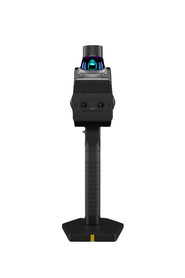
Topcon CR-S2 Portable Handheld SLAM 3D Scanner
Unmatched Speed and Flexibility
The Topcon CR-S2 is a lightweight, handheld 3D SLAM scanner built for today’s construction and survey professionals.
- Ultra-Fast Scanning: Up to 200,000 points per second
- Range: Up to 70m (230 feet) at 80–90% reflectivity; effective to 131 feet at 10% reflectivity.
- High precision: Centimeter-level accuracy with relative accuracy <2 cm, absolute accuracy <3 cm, and RTK horizontal 0.8 cm + 1 ppm (vertical 1.5 cm + 1 ppm).
- Full coverage FOV: 360° horizontal × (-7° to +52°) vertical field of view, enhanced by dual 12MP panoramic cameras for real-time colorization and dual 1.3MP VSLAM cameras.
- Manufacturer Warranty: Comes with a 2-year manufacturer warranty.
Starting at $13,000
Every job site is different, so we build each package around how your crew actually works. Tell us the work and we will spec the right configuration.
Tech Data Sheets

Unlike stationary or bulkier systems, the Topcon CR-S2 Portable Handheld SLAM 3D Scanner is a truly portable handheld scanner with fusion-SLAM technology. It captures data while you walk, delivers real-time colorized point clouds and meshes, and maintains centimeter-level accuracy even indoors, in dense forests, or GNSS-denied areas.
Real-time scan registration and processing occurs in the field using the MAGNET Flow app, with later office processing via MAGNET Bridge and cloud collaboration through Topcon Collage Web. The system supports seamless export to standard point cloud formats (LAS, e57, etc.), meshes, and more for integration with your preferred software.

Key Features
- One-Person Operation: Designed for easy, one-person operation with a lightweight 1.3 kg design.
- Multi-Sensor Fusion: Combines MLF-SLAM, VSLAM, and RTK-SLAM technologies to deliver stable accuracy even where GNSS signals are weak.
- Field & Desktop Software: Pairs with MAGNET Flow for on-site control and real-time viewing, and MAGNET Bridge for advanced SLAM processing and volume calculations.
- Real-Time Results: Supports real-time colorization and real-time processing for immediate actionable results.
- Hot-Swappable Power: Backpack kits support hot-swappable dual batteries for extended operation without downtime.
Data Storage: Features a 512 GB internal SSD for high-capacity data storage.
Technical Specifications
- Scan Rate: 200,000 pts/s
- LIDAR Accuracy: 2 cm
- RTK Accuracy: Horizontal: 0.8 cm + 1 ppm / Vertical: 1.5 cm + 1 ppm
- Detection Range: 40 m @ 10% reflectivity / 70 m @ 80% reflectivity
- Field of View: Horizontal 360° / Vertical -7° to 52°
- Cameras: 2x 1.3MP VSLAM / 2x 12MP Panoramic
- Weight: 1.3 kg (with base, battery, and RTK module)
- Environmental: IP64 Dust/Water Rating
- Operating Temperature: -20°C to 40°C
- Battery Life: Approx. 2 hours per battery
Common Questions About the Topcon CR-S2
What is the Topcon CR-S2?
The CR-S2 is a portable, handheld SLAM-based 3D scanner built for fast mobile capture in tight or hard-to-access spaces.
How does the CR-S2 track its position without a fixed setup?
It uses multi-sensor fusion — MLF-SLAM, VSLAM, and RTK-SLAM — combining LiDAR, visual tracking, and inertial data to map its position as you move, rather than relying on a stationary setup or GPS alone.
How accurate is the CR-S2?
About 3/4 in relative accuracy and under 1 13/16” absolute accuracy. With RTK, horizontal accuracy is 5/16" + 1 ppm and vertical is 9/16" + 1 ppm.
What's the range and scan speed?
Up to 230 ft (230 ft) at 80–90% reflectivity, capturing up to 200,000 points per second.
How much does the CR-S2 weigh?
2.87 lbs (2.86 lbs) — the lightest of Topcon's portable SLAM scanners, which is what makes it well-suited to tight interior spaces and long walkthroughs.
What cameras does the CR-S2 use for colorization?
Two 12MP panoramic cameras plus two 1.3MP VSLAM cameras.
What's the CR-S2 best used for?
Tight spaces, progress monitoring, stockpile volume calculations, and combined indoor/outdoor construction site mapping.
What software does the CR-S2 use?
MAGNET Flow for field capture, MAGNET Bridge for processing, with data publishable to Topcon Collage Web for cloud collaboration and review.
How is the CR-S2 different from the CR-S1?
The CR-S2 is lighter (2.87 lbs vs. 4.85 lbs) with a shorter range (230 ft vs. 394 ft) and a lower relative-accuracy spec (13/16" vs. 3/16") — it trades range and precision for portability, making it better for tight or indoor spaces where the CR-S1's longer range isn't needed.
Can the CR-S2 be used indoors and in GNSS-denied areas?
Yes — its SLAM-based positioning doesn't depend on GNSS, so it works indoors, underground, or anywhere satellite signal is unreliable.
What format is the point cloud data exported in?
LAS, e75, and other common formats compatible with standard CAD, BIM, and GIS software.
Is the CR-S2 a good fit for a smaller contractor doing a mix of project sizes?
Its combination of light weight, indoor capability, and stockpile/volume support makes it a versatile all-around choice — the main trade-off is its shorter 230 ft range and lower relative accuracy compared to the CR-S1, which matters more on large open sites.
Not sure the CR-S2 is the right instrument for your work? That happens often. Send us your project details and we will point you to the right tool, even if it is not this one.
Additional information
| Brand | Topcon |
|---|---|
| Model | CR-S2 |


Return policy: Standard stock items may be returned within 14 days of receipt, provided they are in their original condition. Returns are subject to applicable shipping costs and credit card processing fees. Refunds or credits will be processed only after we have received the returned goods. Non-stock and special order items are generally non-returnable, subject to the manufacturer’s return policy.